
Geomatics and the Mountain of God
 Last summer a group of young explorers spent five weeks in Tanzania using advanced Geomatics instruments including GPS and a gravity meter, measuring, plotting and modelling an active and unique volcano. Leica’s Hugh Anderson joined the party and introduced them to a range of Geomatics equipment.
For me, school is but a distant shadow in the background of my mind, but there is one memory that remains clear to this day. At the first registration each term we were required to indicate our chosen course through life. As we were predominantly a farming area there were many Farmers, punctuated by Lawyers, Doctors, Fighter Pilots and even an Astronaut, as we had just entered the “space age”. On one occasion the teacher started at “w” so by the time my name was barked across the classroom I had become engrossed in a map on the wall, so when I eventually realised the teacher was impatiently waiting for a reply it was “err map maker sir”. The die was cast and I was destined to become a Land Surveyor. I knew about maps, but it was my fascination with the one on the classroom wall that prompted my response.
It may be obvious, but to be interested in something, you must first be aware of its existence. Organisations such as Geomatics.org provide a valuable service in bringing Geomatics into schools. One aspect of the initiative is the offer of survey equipment loans to schools so that students can get “hands-on” experience of Geomatics. This facility has been supported by several donations of survey equipment from manufacturers including Leica-Geosystems, Trimble and more recently, Topcon (see GW Sept/Oct 04). The equipment need not lie fallow during the summer holidays, and the geomatics.org.uk team would be keen to hear from people who provide activities for young people during the recess, such as BES Expeditions.
BES Expeditions (formerly ‘The British Schools Exploring Society’) came into existence in 1932 from an educational idea by Commander George Murray Levick RN, a member of Captain Scott’s final Antarctic expedition of 1911 to 1912. The aim is to deliver a once-in-a-lifetime experience that is both challenging and fun and to develop essential skills in each of the Young Explorers taking part, including leadership, communication and teamwork skills that will help them in the future. Their aim is “To provide young people with an intense and lasting experience of self-discovery in a demanding and natural wilderness environment”. Exploration is the key element of such an expedition, but BES Expeditions also involve the Young Explorers in scientific activities.
Like black oil…
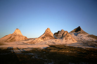
During the summer of 2004, BES Expeditions took their Young Explorers to Svalbard, Iceland and Tanzania. The safari to Tanzania was to the west of Kilimanjaro in part of Africa’s Great Rift Valley. South of lake Natron, against the western wall of the Gregory Rift, and towering above it, is a unique active volcano. Ol Doinyo Lengai, or The Mountain of God as it is known to the Maasai who live in this desolate region, is the only volcano in the world that erupts natrocarbonatite lava. This looks like very fluid black oil, but rapidly turns white as it absorbs water, which can give Ol Doinyo Lengai the appearance of being snow capped.
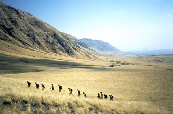
 The Mountain of God was the focus of the expedition, but was 100 Km to the west of Longido where 38 travel weary Young Explorers and 9 Leaders arrived at two o’clock in the morning on 19th July 2004. They would walk across the savannah on the floor of the Gregory Rift, then climb the steep flanks of the mountain, before trekking across the Crater Highlands to mankind’s birthplace at Oldupai Gorge on the edge of the Serengeti plains.
The Young Explorers were aged between 16 and 20, although most were on the younger side, and were from schools across the length and breadth of the United Kingdom, from Inverness to Exeter and from Belfast to London. Only a handful had finished school so the majority returned to their peers in the autumn with tales of their African adventure and the scientific activities they had been involved in. In order to carry out the science, the Young Explorers were divided into three Fires, a Fire being a group of a dozen or so, with two Leaders, a good number to sit round a camp fire!
The diversity of vegetation and birds across the Rift Valley, on Ol Doinyo Lengai and on an extinct volcano near by, Kerimasi, were studied by the Ecology Fire. The Geoscience and Survey Fires were closely related in their activities. The Young Explorers from both Fires were engaged in a Gravity Survey during the trek across the Rift Valley and on the slopes of Ol Doinyo Lengai, and the mapping of the active crater of Ol Doinyo Lengai.
Difficult locations
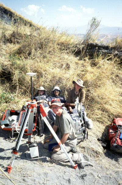
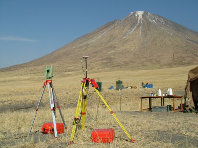
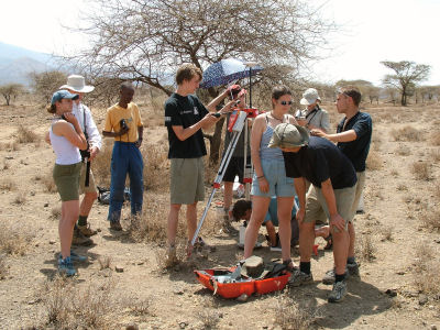 The accuracy required between successive gravity meter readings was to be better than 0.1 metres. In order to achieve this Leica GPS SR530 receivers were used in differential mode. Four base stations were established during the expedition, and these were used for differential GPS observations to each location for the readings with the Gravity meter. These bases were occupied for up to 12 hours and were computed as base lines back to the IGS (International GPS Service) Station at Malindi on the Kenya coast. Malindi was the only IGS station close enough to resolve ambiguities, but the base lines to IGS Stations in the Seychelles and Mbarara in Uganda were also computed as a check on gross error. Using check bases and closed traverses we were able to establish that the precision of the results were better than 0.1m in both plan and height with many of the points showing much better results than this. The Leica GPS SR530 receivers, together with an aluminium tripod and the gravity meter, were backpack packed to some very difficult locations. Gravity readings were taken at the top of Ol Doinyo Lengai and a traverse run down the steep lose slopes of the volcano. Readings were also made on the top of the western wall of the Rift Valley to complete the transit from Longido. The equipment proved its worth in this harsh environment and worked faultlessly throughout the expedition despite the heat and dust, and being used by inexperienced people.
 The Young Explorers also used Leica TCR700 and TPS1200 Total Stations during the course of the expedition. The main task was to take observation to produce a Digital Terrain Model (DTM) of the active crater of Ol Doinyo Lengai. The ideal Instrument for this was the newly launched Leica TPS1200 with its accurate long-range Reflectorless measurement capabilities. A Leica TCRP1205 and lightweight Aluminium Tripod were backpacked up the very steep path to the crater on the summit of Ol Doinyo Lengai, a strenuous climb gaining some 2000 metres in altitude, so the light weight of this Instrument was a blessing! A camp was established on the summit and it was a major logistical effort to supply food and, more importantly, water to support those staying up there and carrying out the survey observations.
Here, the new batteries proved to be a major benefit. Not only were they very light, so did not add much to the heavy loads of water and food that needed to be backpacked to the top, but their long levity meant that they did not need continually bringing down, recharging and taking up again, and when they did need charging it did not take long minimising the intrusion of a generator running at base camp. This Instrument also worked faultlessly in the harsh environment found in the crater of an active volcano again despite being used by inexperienced people who achieved excellent results after only a short lesson in its operation.
The climbers would set off around midnight to benefit from the coolest part of the day and from only being able to see the small section of the path ahead illuminated in their head torches so they were not demoralised by seeing the steep loose path stretching forever upwards. The training on the TCRP1205 would consist of some 20 to 30 minutes with the Simulator on the laptop during the afternoon before they took a nap to rest before the rigours of the night. They only saw the real Instrument once they had recovered from the climb, but were able to record some 3000 points modelling the crater. The data was processed using LSS Vista, by the McCarthy Taylor Partnership, to produce a 3D model of the terrain.
Determining height and GPS accuracy
 Having this modern equipment on the expedition enabled the Young Explorers to carry out two additional tasks. One was to determine the height of Ol Doinyo Lengai. Accurate measurements using the TCRP1205 were made to a point established using the Leica SR530 receiver relative to the IGS Station at Malindi, at the base of the mountain. This has to be the most accurate determination of the height of The Mountain of God ever made, but its value could become superfluous next time Ol Doinyo Lengai erupts again in the manner it did in 1966. Historically, major eruptions occur on a 40 year cycle! The summit of Ol Doinyo Lengai has an Orthometric Height (height above mean sea level) of 2951.6m whilst the GPS, or Ellipsoidal, Height was established as 2962.2m. Five years earlier, Leica SR530 GPS had been used to accurately measure the height of nearby Kilimanjaro.
The other task that this technology lent itself to was to get a feel for the “accuracy” of a Navigated GPS solution. Garmin handled GPS units were used extensively throughout the five-week expedition for navigation and to determine the location for the Ecology Fire studies. The team took advantage of the GPS measurements for the gravity survey to compare the accuracy of a Navigated GPS solution compared to the Computed result. We were only 2° 45’ south of the equator and had good GPS satellite coverage thought the expedition. The results showed that the Navigated positions made with the Leica SR530 GPS receivers were within 5 metres of the computed position in plan and 10 metres in height, although the majority were also within 5 metres in height. The Navigated positions provided by the small hand held Garmin eTrex receivers were within 15 metres in plan, although more than half were within 5 metres, but height was not so good with a difference of 75 metres for one location.
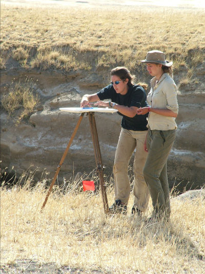 Modern sophisticated Leica Geosystems GPS and Total Stations and the LSS processing software provided the Young Explores with the best tools available for the surveying tasks carried out during their visit to a fascinating part of the earth, but we wanted to give them of taste of another way of making maps, one that has served many earlier explorers and map makers well. Plane Table surveying around the camp showed them the basic principals of making a map and how errors were easily made if care was not taken with setting up and orientation. Interestingly, this activity allowed them to introduce their own creativity into the process of mapping. Drawings of the surrounding mountains, vegetation and animals were added to the empty area around the detail in the centre of the Plane Table.
Most of the Young Explorers and Leaders met for the first time in March 2004 at a “briefing weekend” at Hesley Wood Scout Centre in Sheffield, where they chose which Fire they wished to belong to. A very few had heard of GPS, but none really had an inkling of what Surveying (Geomatics) was about. There was much to do during that hectic weekend so most were still “in the dark” when they arrived at Heathrow Airport at 7am on Sunday 18th July. Five weeks on the BES expedition to Tanzania gave them a real taste of what Geomatics was all about. This really was an opportunity to bring awareness of Geomatics to young people starting out in life and into their schools. Most of the Young Explorers are now back at school completing their final year before going on to University and will talk about their African adventure, how they measured the gravity across Africa’s Great Rift Valley fixing positions with GPS, mapped the crater of an active volcano with a Total Station and made their own unique maps using a Plane Table. This type of activity, together with innovations such as Geomatics.org, will bring our profession to the attention of young minds. Those that took part will not forget this safari and its activities in a hurry, and their experiences will be communicated to the wider audience.
Geomatics World January/February 2005
This article was published in Geomatics World
Issue No 2 : January/February 2005 : Volume 13
![]()