
Determination of the Accuracy of a Navigated GPS Point
Introduction
Both the Survey and Geosciences Fires were involved in collecting DGPS data to provide accurate height information for the Gravity Meter Survey during the expedition. This was carried out using Leica SR530 Survey GPS. Garmin handled GPS units were also used extensively throughout the five-week expedition for navigation, determination of Gravity Meter sites and to determine the location for the Ecology Fire studies.
The Garmin handheld GPS units provided a Navigation (Code only) solution. The Leica SR530 GPS units also provided a Navigation (Code only) solution as well as collecting the data for post processing to obtain the required results for the Gravity Meter readings. The opportunity was taken to compare the accuracy of a Navigated solution with the high accuracy results obtained from the phase measurement calculations.
Results
The location of the expedition was some 2° 45’ south of the equator so satellite coverage was good throughout the duration.
The results showed that the Navigated positions made with the Leica SR530 GPS receivers were within 5 metres of the computed position in plan and 10 metres in height, although the majority were also within 5 metres in height.

Figure 2 Simultaneous collection of GPS and Gravity Meter data. The Garmin handheld GPS unit is held next to the Leica SR530 receiver and the Navigation (Code only) solutions are recorded for both units.
The Navigated positions provided by the handheld Garmin eTrex receivers were within 15 metres in plan, although more than half were within 5 metres, but height was not so good with a difference of 75 metres for one location.
The reason the Leica SR530 GPS receivers provided a better navigation solution than the Garmin handheld GPS units is because the Leica GPS receivers continually “improve” the position information during the occupation of the point, whilst the Garmin GPS units provide a single solution. This refining of the position by the Leica units could be seen on the display and often resulted in the question being asked as why a stationary unit appeared to be moving.
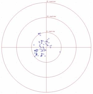
Figure 3 Leica SR530 Receivers. Plot of the plan differences for the Navigation (Code only) solution from the Leica SR530 receivers when compared with the post processed computed positions using phase measurement of the carrier frequencies with the Leica SR530 receivers.
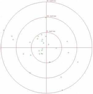
Figure 4 Garmin eTrex handheld units. Plot of the plan differences for the Navigation (Code only) solution from the Garmin eTrex handheld units when compared with the computed positions using phase measurement of the carrier frequencies with the Leica SR530 receivers.
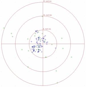
Figure 5 Garmin eTrex handheld units. Plot of the plan differences for the Navigation (Code only) solution from the Leica SR530 receivers (shown in blue) and the Garmin eTrex handheld units (shown in green) when compared with the computed positions using phase measurement of the carrier frequencies with the Leica SR530 receivers.
Hugh Anderson MRICS MInstCES BA(Open), Survey Fire Leader
![]()