 The concept of Photographic Intersection predates the invention of photography itself. Surveyors produced drawings in the field by projecting an image onto a surface using a lens, then tracing in that image. Maps were then produced from these images in much the same way as we use photographs for Terrestrial Photogrammetry today. Photographic Intersection is the determination of the 3D co-ordinates of a point in space using the known location and orientation of two or more photographs containing that point.
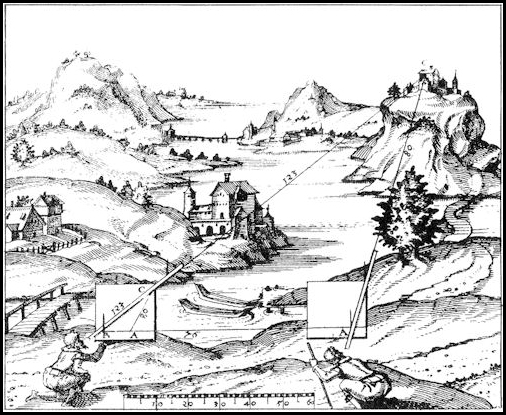
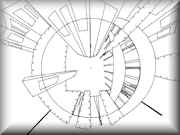
The illustration is from “Novum Instrumentum Geometricum” by Leonhard Zubler of Zurich, which was published in 1614 by Ludwig Konigs of Basle.
Why use photographs?
Using photography as a means of data capture is a rapid way of gathering large amounts of information. Direct measurement methods are time consuming on site and, although it may sound obvious, only those points measured are captured. A photograph may be taken to capture a limited amount of data at the time, but a huge amount of additional information is captured at the same time for no extra effort. This information can be extracted later without the need to revisit the site, bearing in mind that the site could have changed, or may even have ceased to exist.
Low cost equipment
Photogrammetric cameras tend to use wide-angle lenses to capture a large amount of information and ensure good intersection of the rays to the points of interest. However, if we replace the Wild P32 on the Wild T2 with say a 35mm camera with a 1000mm lens we have a different, but very useful device. This focal length covers a zone approximately 2 degrees on the long side and 1 degree 20’ on the short side, or some 7200” x 4800”. If the resultant image could be digitised to a matching pixel resolution, which is possible with equipment available today, then each pixel would represent one second of arc in the image.
 |
 |
|
|
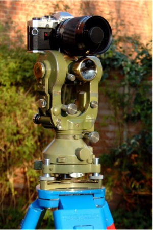
An Olympus OM10 35mm film camera, fitted with a 500mm lens and 2x teleconverter (giving a focal length equivalent of a 1000mm lens) mounted on a Wild T2 1″ theodolite. |
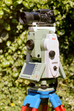
A 6Mp Fujifilm S7000 digital camera, which has a 6x zoom lens (35mm equivalent – 35mm to 210mm) fitted with a 2x teleconverter (giving a focal length equivalent of a 420mm lens) mounted on a Leica TPS1205 Total Station. |
The concept of Photographic Intersection
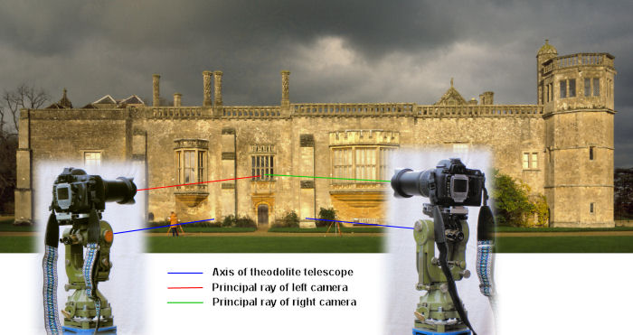
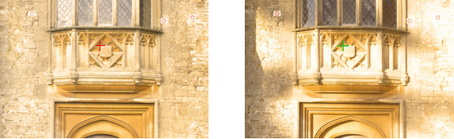
The camera is mounted on the theodolite so that the principal ray is parallel to the axis of the theodolite. The position and orientation of the theodolite is known for each exposure. Any deviation between the camera axis and the principal ray of the lens and the front nodal point of the lens and the known point of the theodolite can be easily calibrated so that location of the front nodal point of the lens and orientation of the principal ray in space is known for every image. The internal information, such as lens focal length and image size, are also known for each image so that for any point in the image the horizontal and vertical deviation from the principal ray can be calculated by trigonometry, which means that for any point in the image the origin and orientation is easily determined. Selecting a point in one image and the same point in another image therefore provides sufficient data to calculate the 3D co-ordinates of that point. If the same point is selected in a third (or subsequent) image there is sufficient data to also get a quality for the result. In the ideal situation, the left and right principal rays would cut at right angles.
The photographs of Lacock Abbey were taken by David Stevens on 14th November 1984 with a Wild P32 Photogrammetric camera and used to produce the frontispiece for the October 1985 Photogrammetric Record (Vol. XI No. 66). This was to commemorate the 150th anniversary of the first negative taken by William Henry Fox Talbot (1800-1877) of the oriel window of Lacock Abbey in Wiltshire. The Abbey was founded in April 1232 to house the convent of Augustinian canonesses.
![]()
 Photographic Intersection – How I Developed My Ideas
A brief history of the events and ideas that developed into my views on Photographic Intersection.
 Photographic Intersection – The Technicalities
The technical details that support Photographic Intersection.
 Panoramic Photography As A Survey Tool
A paper describing the development of an optical device for use in detail surveying, which enables panoramic photographs to be taken using conventional cameras and lens systems, and suggests how such a device can be used as a tool in some survey disciplines.
Author: Hugh Anderson, 1st August 1978.
 Patent No. 1493188
Optic for instantaneously photographing an horizon of 360°.
 360° Panoramic Optic for Photographic Intersection
A Conical Mirror or Prism to provide a full 360° panorama for surveying and mapping.
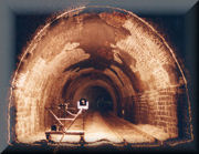 Photographic Intersection by Light Line for Measuring Tunnels
Images of the FITS and HITS units being used to measure tunnel profiles. A Light Line is projected onto the tunnel surface defining a plane through the tunnel at the particular chainage require. This is photographed and digitised to produce an accurate profile of the tunnel. A 1000 metres of tunnel could be measure every 10 metres in a single nights possession using this technique.
![]()