There are a variety of measurement methods ranging in price from a few £s to tens of thousands of £s and each has its own merits and benefits. In many circumstances non-contact measurement is desirable due accessibility issues or the delicacy of the subject.
Towards the end of 2020 a low cost non-contact method using 360° Panoramas became available with an application developed by Arthur van den Enk Hauwert in the Netherlands. PaMe is straight forward to use so there is NO learning curve and measurements are obtained from a pair of 360° Panoramas captured with affordable, available, off-the-shelf and reliable equipment.
PaMe comes in two variations: PaMe Wizard is a Krpano add-on providing a ‘measure tool’ in a ‘Krpano driven’ Virtual Tour whilst PaMe Light is a web based tool that allows you to just drag and drop your 360° Panoramas from your desktop. Both versions have three methods of controlling scale: “Known distance between panoramas” (base line), “Known height” and “Known length” in the subject area. PaMe Wizard has a fourth option which is to use GNSS locations for the two Panoramas, but consumer GNSS values are not sufficiently accurate in most case so it would probably require a survey (engineering) grade unit such as supplied by Leica Geosystems and Trimble to achieve a good result with this option.
GNSS = Global Navigation Satellite System including the USA’s GPS, Russian GLONASS, European Union’s Galileo and China’s Beidou.
PaMe is a tool for taking direct measurements from the pair of 360° Panoramas, such as when using a tape or laser distancer, rather than a co-ordinate measurement method so multiple ‘set ups’ do not need to be ‘related’ to each other making this a versatile and flexible option. This method benefits from using photography in the shape of 360° Panoramas as a photographic image includes colour and texture information and measurement can be taken at any time without the need to revisit the site, which may have changed or no longer be accessible or even no longer exist.
The two options for controlling scale, ‘known distance between panoramas’ and ‘known length’, not only give the method flexibility but also provides a means for checking the results if both are used for the same pair of 360° Panoramas. A ‘known length’ can be introduced into the subject using a levelling staff, ‘target bar’ of known distance between the targets (e.g. a subtense bar) or the known distance between two points, as well as measuring the distance between the 360° Panoramas providing two methods of extracting measurements in PaMe. This is illustrated in Setup Two and Setup Three’ in the Examples.
The cost of this measuring system will depend on a number of factors, but will always be considerably cheaper than other non-contact methods and easier to use.
If you already capture 360° Panoramas then all that is required to obtain measurements is Krpano and PaMe Wizard and you can use PaMe Light to evaluate the process before making this financial investment.
If you do not currently capture 360° Panoramas you may have some of the equipment required already, such as a camera to which a ‘fisheye’ lens can be attached, a tripod to which a panoramic head can be attached, a levelling staff and a laser distancer. To use a camera with a ‘fisheye’ lens rotated on a panoramic head you will need PTGui to ‘stitch’ the captured images to create the equirectangular images required for use with PaMe.
If you are starting from scratch there is a choice of 360° cameras which have their own software for creating the equirectangular images. You will need something to support the camera (e.g. pole, selfie stick, monopod or tripod) and something to measure the distance between the panoramas (e.g. laser distancer, which is easier to use than a tape and does not cost much more).
There are some considerations when capturing the 360° Panoramas:
The two panoramas must be in the same horizontal plane;
The location of the panoramas must be marked so that they can be orientated in PaMe;
There needs to be a measured distance to ‘scale’ the setup, which can be the distance between the panoramas or a ‘known distance’ in the subject area or both.
The panoramas can be marked on the ground to provide the target for orientation in PaMe and to measure between them for the ‘Known distance between panoramas’, but it is essential that the panoramas are truly vertical above the marks which can be achieved by using a ‘bubble’ if using a pole or a plumb bob if using a tripod. An alternative is to use two tripods with the camera on one and a target on the other for the first panorama then swapping them over for the second. This means that the distance between the actual panoramas can be measured and provides a target for orientating the panoramas in PaMe. Another alternative is to use a lightweight beam separating the camera and target (or possibly two cameras) so that the two 360° Panoramas are always a known distance apart.
Using PaMe is straight forward; the two panoramas are imported into the application and aligned, the ‘scale’ distance entered and you are ready to measure.
For almost a quarter of a century I was Technical Support with Leica Geosystems in the UK and our Customer base included a number of UK based Archaeology Organisations who used Leica Geosystems (Wild Heerbrugg) equipment for measurement. As well as providing support for the various measuring equipment I provided training and support for capturing 360° Panoramas to add ‘natural’ colour to LiDAR point clouds.
In 1973/4 I mapped Annesley Hall, Nottinghamshire, in its entirety at 1:50 scale while working for BKS Surveys and we pioneered terrestrial stereo photogrammetry to map the elevations. There was a myriad of rooms of various sizes and shapes to map and I had the idea of using 360° Panoramas as a measurement tool for which I was awarded a patent in 1978. At the time, technologies such as the personal computer and digital photography were still in the future but were developed and evolved to the point where my idea has become a reality with the PaMe application.
There is a wealth of information relating to 360° Panoramas on the Internet.
If you have any questions you can contact me at: 360musafa@gmail.com and I will answer them the best I can.
![]()
 |
PaMe – Measure from 360° Panoramas Some notes on using PaMe. PaMe is straight forward to use with ‘on screen’ instruction and good tutorials so there is NO ‘steep learning curve’. PaMe Light is excellent for experimenting with the application before committing to purchase PaMe Wizard. |
|
 |
Use 360° Panoramas for ‘Real Life’ Measurement PaMe provides two applications for getting measurements from 360° Panoramas. PaMe Wizard is a Krpano add-on providing a ‘measure tool’ in a ‘Krpano driven’ Virtual Tour. This full version contains four ways of measuring, with the ability to save the calibrations (which can be ‘locked’) and provide ‘real time’ measurements. PaMe Light is a web based tool that allows you to just drag and drop your 360° Panoramas from your desktop. This light version has three ways of measuring. |
|
 |
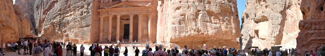
Example Setups Some examples which were originally used to evaluate the accuracy of using equirectangular images as a ‘photographic The ‘points’ were circular targets which were measured relative to the 360° Panorama locations using a Kern DKM2-A 1″ Theodolite and Leica DISTO. |
|
 |
PTGui PTGui is panoramic stitching software for Windows and Mac OSX. Originally developed as a Graphical User Interface for Panorama Tools (hence the name), PTGui now is a full featured photo stitching application. Use PTGui to stitch any number of photos into a panoramic image. |
|
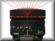 |
Finding the Nodal Point of a Lens For a lens to be used effectively for 360° Panoramas the location of the Front Nodal Point (No Parallax Point) must be accurately determined so that the camera/lens combination can be rotated about this point. |
|
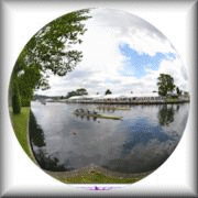 |
360° Panoramas If a picture is worth a thousand words then a panorama must be worth ten thousand, especially a 360° (or spherical) panorama |
![]()