
Rift Valley profile
Fifteen measurements were acquired in a profile almost 100 km long across the rift valley (Figure 21). The data still have to be terrain corrected, which will be done at Edinburgh University using a regional digital terrain model for far zones combined with corrections obtained in the field for local zones. The terrain corrections are not expected to be significant except in the vicinity of the cliffs at the western edge of the rift valley. The Bouguer anomaly profile as it stands shows the strong negative associated with the EAR (Figure 22). These data fit well with existing data from the region and, once the terrain corrections have been finalised will be supplied to BRG for addition to the regional database.
Ol Doinyo Lengai profile
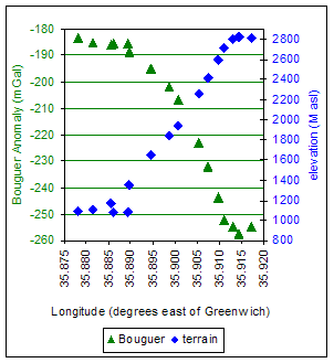 The gravity profile from the Ol Doinyo Lengai flattens off at the top and the bottom of the volcano. This means that the survey captured the whole of the anomaly associated with the volcano, which means that it can be interpreted and modelled. These data will be used in a fourth year project by an Edinburgh University Geophysics student. They require more serious terrain corrections which will be calculated by digitising the 1:50,000 contour map of the volcano but taken at face value the volcano appears to have a strong negative Bouguer anomaly, over and above that of the rift valley.
The short profile obtained in the rift valley in front of the volcano may allow the gravity effects of the rift valley to be separated from the anomaly due to the volcano.
Figure 20 Gravity and terrain profiles of Ol Doinyo Lengai. The gravity profile flattens out at both the top and the bottom, indicating that the whole anomaly has been covered.
In this digital age there is little value in placing large amounts of numerical data in this report. The Rift Valley profile data will be publicly available from BRG (see Calibration of the gravimeter above). Once the Lengai data have been interpreted and modelled they will be available on the expedition website (see Observations from the active crater of Ol Doinyo Lengai below).
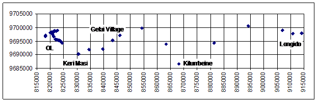
Figure 21 Map of gravity survey points across the Rift Valley from Longido to Ol Doinyo Lengai. The entire traverse is just less than 100 km long. Coordinates are UTM (metres, zone 6): each grid square is 5 km x 5 km.
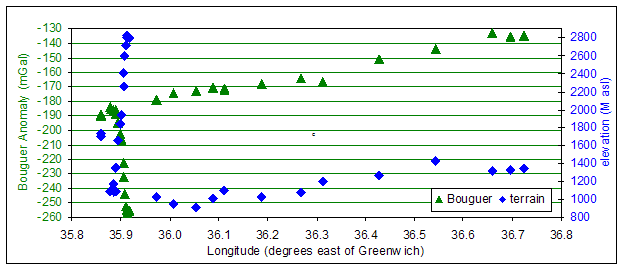
Figure 22 Bouguer gravity anomaly and terrain profiles of data obtained across the EAR. The strong negative Bouguer anomaly associated with the rift valley is evident. The peak at 35.9°E is Ol Doinyo Lengai which itself appears to have a strong negative Bouguer anomaly.
Conclusions from the gravity survey
The gravity survey was successful in obtaining a regional profile across the rift valley which can be added to the international database hosted by BRG, and a profile of Ol Doinyo Lengai which will be interpreted and modelled by Edinburgh University in 2005.
Ewan Laws
![]()